GPS Map Cam: Phone Tracker
- 4.2
- Rating
- 5.00M
- Installs
- Free
- Price
 Analysis by App-foxy
I approached GPS Map Cam: Phone Tracker as a practical Maps & Navigation app rather than as a full replacement for a dedicated navigation service. Its idea is easy to understand: combine location-aware photography with a way to view people or devices in a family circle. That combination can be useful, but it also places trust at the center of the experience. A camera app handles personal images, while a locator deals with information about where people are. I found that the app makes the most sense when everyone involved understands what is being shared and why.
In everyday use, I would recommend it to someone who wants location context attached to photos and a simple circle-based way to keep track of relatives or close contacts. I would not treat it as an automatic safety solution, and I would not install it casually on a phone used by someone who is uncomfortable with location sharing. The appeal is convenience; the responsibility is making deliberate choices before using the more sensitive parts.
What the app is trying to do
The app comes from Amobear Application Publishing and is listed as a free app for Android users. It belongs to Maps & Navigation, although its camera element gives it a slightly different feel from a conventional map utility. The store summary presents two connected uses: taking geotagged shots and viewing locations inside a family circle. That pairing is important because it means the app is not only about finding a route from one place to another.
You May Also Like

 Blood Strike: 2.5 Anniversary
Blood Strike’s Loadouts Turn Every Drop Into a Tactical Gamble
A close look at Blood Strike’s custom loadouts: how fast access to signature weapons reshapes its battle royale rhythm, rewards preparation, and narrows the gap between fights.

 Pandora - Music & Podcasts
Pandora’s Music Is Easy to Start, but Harder to Recover
Pandora’s strength is its low-effort path from a seed to a station. Its weak spot is how much confidence it asks you to place in connection, setup, and quiet recovery.

 8 Ball Pool
 Is Built on Rivalries, Rematches, and Routine
A close look at the rivalries, rematches, shared routines, and unanswered safety questions that turn a quick pool match into a persistent mobile community.

 Samsung Music
’s Quiet Strength Is Playing What You Already Own
Its reach comes less from spectacle than from dependable access to a personal library. That simplicity is both the app’s strongest retention engine and its ceiling.

 AccuWeather: Weather Radar
AccuWeather Review: A Quick, Clear Forecast for Everyday Decisions
For everyday plans, the best forecast is the one you can understand quickly. AccuWeather makes rain timing, radar, and local conditions easy to act on, with a few trade-offs.

 Hill Climb Racing
Why Hill Climb Racing Still Turns Crashes Into One More Run
A tiny car, a bumpy hill and one more upgrade: Hill Climb Racing keeps resurfacing because its simple chaos makes every near-miss feel personal.
More From Our News Desk



When I think of a normal map app, I expect route planning, traffic information, saved places, and turn-by-turn guidance. GPS Map Cam: Phone Tracker sits closer to a location diary and a small-group locator. A photo can carry a sense of place, while the circle view is aimed at keeping selected people visible to one another. Those are different jobs from navigation, and I found it more helpful to judge the app on that basis instead of expecting it to behave like a traditional driving tool.
The app has an average rating of 4.1 from around 3.6 thousand ratings, with over 1 million installs. Those figures suggest that the concept has reached a substantial audience, but they do not remove the need to check whether its location and camera behavior fit your own comfort level. It is free to install, while in-app purchases range from $3.99 to $26.99 per item. I would therefore begin with the basic experience and only consider an upgrade after deciding that the core workflow is genuinely useful.
My first impression of the camera side
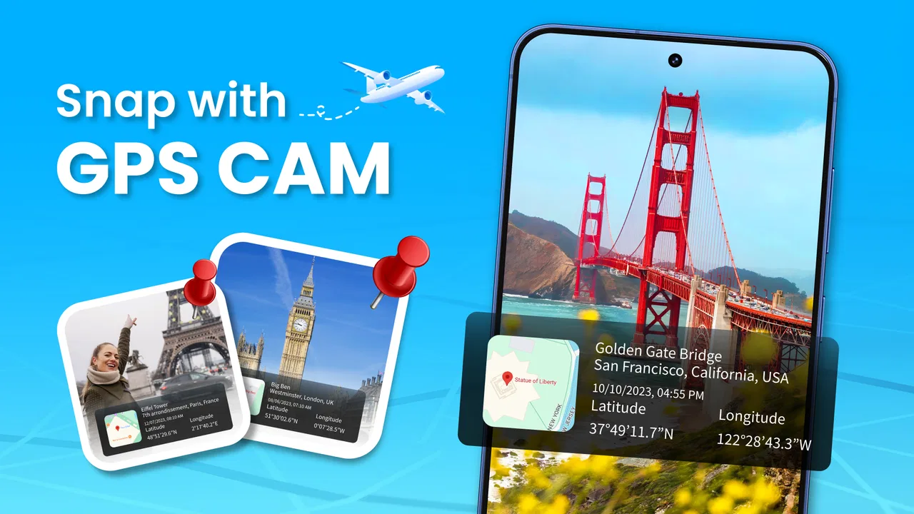
The most distinctive part is the connection between a picture and its geographic context. A geotagged image can be more useful than a regular snapshot when I am documenting a trip, recording the position of a viewpoint, or trying to remember exactly where I found something. It turns a photo into a small location record rather than just a visual memory.
That feature is especially practical for people who take many reference photos. For example, I could photograph the entrance to a large park, a temporary parking area, or a trail junction and later use the image together with its location context. This is more reliable than trying to remember a place from the picture alone. My tip is to treat each image as a note: take the shot when the location matters, and avoid creating a large collection of ordinary pictures that do not benefit from geographic information.
There is also a privacy trade-off that is easy to overlook. A geotag can reveal where a picture was taken, and that may be harmless for a public landmark but sensitive for a home, workplace, school, or private gathering. Before sharing a location-aware image, I would look at the scene and ask whether the place itself is information I want another person to have. The useful habit is to separate “this photo looks fine” from “this photo reveals a location I am comfortable sharing.”
How the family circle changes the experience
The family locator side is more personal than the camera side because it concerns people rather than places. A circle can be helpful when relatives want a shared view of whereabouts, but it only works well when participation is clear and voluntary. I would set it up with the people involved present, explaining what the circle is for and who can see the location.
A realistic example would be a family meeting at a busy outdoor venue. Instead of repeatedly calling to ask where everyone is, members of the circle could use the location view to find one another more easily. Another example is coordinating a pickup when plans shift. In both cases, the benefit comes from reducing small communication problems, not from monitoring someone continuously.
That distinction matters. A family locator should support an agreed plan, not replace conversation or become a reason to demand constant visibility. If one person feels pressured to join, the technical convenience is not worth the loss of trust. I would also avoid using it as the only response to an emergency. A location display can be delayed, misunderstood, or unavailable, so urgent situations still require the appropriate direct help.
Before inviting someone, I would decide how long the circle should remain active and whether every member really needs access. A small circle is easier to understand than a broad group with unclear boundaries. I would also review the membership after a trip, event, or temporary arrangement ends. Removing people who no longer need access is a simple but important privacy habit.
Trust begins with visible choices
The app’s most sensitive moments occur when it asks to work with location or the camera. I would read each system prompt instead of tapping through it automatically. Location access is central to the app’s stated purpose, but that does not mean every situation deserves the same level of access. If the operating system offers a choice between limited and broader access, I would select the least access that still supports the task I am performing.
The same approach applies to the camera. I would allow camera access when I am ready to take a location-aware picture, then revisit the permission later if I stop using that part of the app. This is not about assuming bad behavior; it is about keeping the phone’s controls aligned with current use. An app can be useful today and unnecessary next month, so permissions should not become permanent by habit.
On Android, the app requires version 7.0 or later, which makes it available to a wide range of devices. Compatibility is convenient, but older phones may offer a less comfortable experience if storage, battery, or system permission controls are limited. I would pay attention to how the phone behaves during a normal outing rather than judging the app only from a short indoor test.
The current version is 1.0.4_20251022, and the app was released on October 23, 2025. Because it is a relatively new product, I would keep an eye on updates and read the permission prompts again after major changes. An update can improve usability, but it is also a good moment to check whether the choices I made during setup still match my expectations.
Data-sensitive situations deserve extra care
There are three situations where I would slow down before using the app. The first is photographing a private address. A geotagged image of a front door, office entrance, or child’s regular destination can communicate more than intended. I would avoid sharing that kind of image unless the recipient genuinely needs the information.
The second is adding a person to a circle. I would never add someone simply because I know them. The relevant question is whether they understand the arrangement and want to participate. A locator is more trustworthy when every member knows who is included, what the circle is used for, and how to leave it.
The third is using the app around children or other vulnerable people. I would keep the circle as small as possible and avoid treating location visibility as proof that someone is safe. The app can help with coordination, but it should not encourage a false sense of certainty. A phone may be offline, misplaced, or unavailable, and a map position still needs human interpretation.
My practical workflow would be to create a purpose-specific circle, use it during the relevant activity, and review it afterward. For a family outing, that might mean checking membership once everyone has joined, using the location view only when coordination is needed, and removing temporary participants when the outing is over. This is more disciplined than leaving every old connection active indefinitely.
Where it differs from ordinary alternatives
Compared with a standard map application, GPS Map Cam: Phone Tracker has a narrower but more personal focus. A conventional map is usually better when I need routes, directions, business information, or broad geographic search. I would choose that kind of tool for driving across town or planning a journey. I would choose this app when the important question is “where was this photo taken?” or “where are the people in our agreed circle?”
It also differs from a basic camera. A regular camera may be the better choice for someone who wants the fastest possible photo workflow and has no interest in location context. The advantage here is not simply taking a picture; it is making place part of the record. If I never use that context, the extra location-related decisions may feel unnecessary.
Family communication tools can sometimes be better for a group that mainly needs messages, calls, or shared schedules. GPS Map Cam: Phone Tracker is more suitable when the location view is the central reason for joining. I would avoid asking a whole family to install it if only one person occasionally wants to share a geotagged picture. In that case, a normal camera and a familiar messaging method may create less friction.
The app’s strongest use case is therefore quite specific: a small group that agrees on location sharing and also values photos tied to place. Its weakest use case is someone looking for a complete navigation suite, a professional mapping tool, or a completely passive camera experience.
Questions I would settle before installing
A reader may reasonably wonder whether the app is suitable for an older phone. The minimum operating-system requirement is Android 7.0, so the key first check is the phone’s software version. After that, I would make sure there is enough storage for photos and that the device’s location and camera controls are easy to access. Compatibility alone does not guarantee that the workflow will feel comfortable on every handset.
Another question is whether the free installation is enough to judge the app. In my view, yes: I would test the camera workflow, examine the circle setup, and see whether the app fits a real routine before spending anything. Since optional purchases range from $3.99 to $26.99 per item, I would not buy an upgrade simply to unlock possibilities I have not yet used. The right value depends on how often the location features solve an actual problem.
People also ask whether a family locator removes the need to contact someone directly. I would say no. I would use it to reduce unnecessary calls during coordination, but I would still message or call when timing, safety, or consent is unclear. A map position is context, not a conversation.
Finally, I would ask whether every photo should carry location information. Definitely not. For public places and travel notes, it can be useful. For private homes, routine destinations, or images intended for a wide audience, I would be selective. The best experience comes from choosing location tagging deliberately rather than treating it as an automatic default for every picture.
My cautious verdict
I found GPS Map Cam: Phone Tracker interesting because it links two things people often keep separate: recording where a photo was taken and coordinating with a trusted group. That makes it more purposeful than a generic camera, but also more demanding than a simple map. The app earns its place when I have a clear reason to use both sides of the idea.
My recommendation is for families, couples, and small groups who can agree on boundaries and want a lightweight location-sharing routine. I would especially consider it for trips, outdoor meetups, or situations where geotagged photos are genuinely useful. I would skip it if I only need driving directions, if location sharing would create tension, or if I prefer not to connect personal photos with places.
The developer is Amobear Application Publishing, the content rating is Everyone, and the app is free to start. Those details make trying it accessible, but the important decision is still personal: can I explain what information is being shared, with whom, and for what purpose? If the answer is yes, this app can be a handy combination of geotagged photography and consent-based family coordination. If the answer is unclear, I would choose a simpler camera or a conventional navigation app instead.
FAQs for GPS Map Cam: Phone Tracker
01What features does GPS Map Cam: Phone Tracker offer?
GPS Map Cam: Phone Tracker provides real-time location tracking, photo geotagging, and route history features. Users can capture photos with embedded location data and timestamps, making it easier to track locations and movements. The app also allows sharing of location details with friends or family, enhancing safety and connectivity.
02Is GPS Map Cam: Phone Tracker compatible with all devices?
The app is compatible with most Android and iOS devices. However, performance may vary based on the device's GPS capabilities and operating system version. It’s essential to check the app store for specific compatibility details and ensure your device meets the necessary requirements for optimal performance.
03How accurate is the location tracking in GPS Map Cam: Phone Tracker?
The app offers highly accurate location tracking, utilizing GPS technology to provide precise details. However, accuracy can be affected by environmental factors such as signal strength, obstructions like buildings, and weather conditions. Regular updates help improve the app’s reliability and tracking precision.
04Is my data secure with GPS Map Cam: Phone Tracker?
Yes, GPS Map Cam: Phone Tracker prioritizes user privacy and data security. The app employs encryption protocols to safeguard your location data and personal information. Users should review the app’s privacy policy to understand data handling practices and ensure their comfort with the app's terms.
05Are there any in-app purchases or subscriptions in GPS Map Cam: Phone Tracker?
While the base version of GPS Map Cam: Phone Tracker is free, it may offer in-app purchases or subscription options for additional features. These can include enhanced tracking capabilities, ad removal, or advanced geotagging. Users can choose to upgrade based on their needs and preferences.
Pros
- User-friendly interface for easy navigation.
- Accurate GPS tracking in real-time.
- Customizable map settings for personalization.
- Offline map access for remote areas.
- Seamless integration with social media.
Cons
- Consumes significant battery power quickly.
- Requires constant internet connection.
- Limited features in free version.
- Occasional location inaccuracies.
- High data usage for live tracking.

GPS Map Cam: Phone Tracker
Gallery